


Landsat 7 Products
The Landsat program, originally known as the Earth Resources Technology Satellite (ERTS), was proposed in 1965 by the US Geological Survey(USGS) as a civilian satellite program. NASA started builiding the first satellite in 1970 and have launched 6 spacecraft successfully (Landsat 6 was lost at launch). In December 2009 all Landsat archive products became free to the public on the USGS website. The USGS own and operate the Landsat program.
Landsat 7 was launched on the 15th of April 1999. Currently the satellite is operational in SLC off-mode. It is a polar, sun-synchronous satellite orbitting the earth at 705 km. 'Landsat 7 carries the Enhanced Thematic Mapper plus instrument (ETM+,) with the equivalent capabilites of the Thematic Mapper (TM) on board Landsat 4 and Landsat 5. In addition to this there is a 15 m panchromatic band, a 60m thermal band, and an on-board radiometric calibration and data recorder. On 31 May 2003 the Scan Line Corrector (SLC) failed resulting in gaps of missing data in the imagery. All acquisitions subsequent to this malfunction are supplied in SLC-off mode.

Landsat 7 image showing gaps of missing data.
ETM+
Sensor type : Optical
Reference System : Worldwide Reference System 2 (WRS2)
Scanner type : Whisk-broom
Swath : 183km
Bands : 8 bands
Band type : Multispectral
Spectral range : 450-12500nm
Spatial resolution : 15m, 30m, 60m
Qauntization : 8 bit
Image size : 183km x 170km
Taskable : Yes
Processing software : Level 1 Product Generation System (LPGS) provided by the USGS to level 1 G or level 1 T (level 3 orthorectified)
The Enhanced Thematic Mapper plus (ETM+) instrument on board Landsat 7 records panchromatic (black and white) imagery at a spatial resolution of 15m, multi-spectral imagery of six bands in the blue, green, red, near-infrared and shortwave infrared electromagnetic band widths with a spatial resolution of 30m, and two thermal bands with a spatial resolution of 60m. The thermal bands are resampled to 30m resolution.

A table of Landsat 7's bands and their different properties.
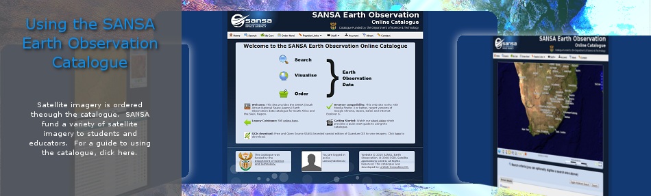
Landsat 7 imagery is collected and archived at SANSA Space Operations. The imagery is funded to students. To download landsat 7 imagery please visit the SANSA Earth Observation Catalogue. For help on using the catalogue, please read Using the SANSA Earth Observation Catalogue.
General satellite image processing levels explained
Level 0 : Raw instrument data collected at the sensor and is the input data to the ground segment processor. Raw data is not in a usable format for customers.
Level 1 : Radiometric corrections of the differences in sensitivy of the detectors based on in-flight calibrations (Level 1A). Geometric corrections take into account both internal and external orientations of the satellite in relation to the earth to account for scan line misallignment and non-uniform pixel sizes (Level 1B). Level 1 imagery is often referred to by customers as "raw" imagery as there is still a great deal of processing required before spatial or spectral analysis can be performed.
Level 2 : Georeferenced into a standard map projection. Level 2A is geolocated to the satellite predicted position at the time of the acquisition and still has location errors (not recommended for spatial analysis). Level 2B is geolocated against a georeferenced reference image and rectified using ground control points (GCPs) in both images with a positional accuracy of the spatial resolution of the original image excluding mountainous areas.
Level 3 : Orthorectification using GCP points, reference imagery and a digital elevation model (DEM) to accurately locate areas of high relief. The positional accuracy is expected to be the same as the spatial resolution of the original image including mountainous areas.
USGS ground segment LPGS explained
The USGS have their own processing levels defined for their Landsat 7 imagery. The Level-1 Product Generation System (LPGS) products are defined in further below:
Level 1R : Radiometrically corrected (equivalent to Level 1A)
Level 1G : Radiometrically and geometrically corrected (equivalent to Level 2A) using the predicted or definitive ephemeris if available.
Level 1T : Orthorectification using GCP points derived from the Global Land Survey (GLS) 2005 reference imagery and the Shuttle Radar Topographic Mission (SRTM) 90m DEM. The projection is WGS84 UTM.
SANSA Landsat 7 processing explained.
SANSA collects and archives Landsat 7 imagery falling within the Southern African Democratic Countries (SADC) footprint. SANSA use the USGS's LPGS to bring the Landsat 7 imagery to Level 1 G. From there SANSA use their own image processing setup to produce Landsat 7 products. Landsat 7 products and processing levels are specified and ordered on the SANSA Earth Observation Catalogue. The panchromatic and multi-spectral imagery can be fused to produce a pan-sharpened multi-spectral image at a resolution of 15m. Further processing of imagery includes ground control point collection, orthorectification, at sensor reflectance calculations, mosaicking, clipping and atmospheric correction. The different Landsat 7 processing levels offered at SANSA are defined below.
Level 2A : Geolocated using satellite position (import only).
Level 2B : Geolocated using GCP points (auto GCP collection).
Level 3Aa : Orthorectification using GCP points, reference imagery and 20m DEM. Suitable for spatial analysis including digitising.
Level 3Ab : Reflectance values at top of atmosphere (at scanner reflectance). Suitable for visual interpretaton, spectral signature analysis, classification and derivation of indices (NDVI, EVI).
Level 3B : Mosaicking of many images into a larger single image.
Pan-sharpen : Fusion of the multispectral imagery with panchromatic imagery at the resolution of the panchromatic imagery.
In addition to this, you may specify additional processing options when ordering Landsat 7 imagery through the SANSA Earth Observation Catalogue. These additional options are:
Clipping : Select a subset of a landsat 7 image.
Reprojection : Default projections include UTM and Geographic coordinate.
Format change : Default format are Geo TIFF (tif), JPEG2000 or PCI pix.
Useful guides and technical documents.
Landsat programme technical information
About Resources
On this page you will find a variety of links with descriptions to earth observation resources, ranging from user guides, commercial catalogues to free data sources, other portals and softwares. Should you know of any other interesting links, please send them to us and we will add them to the resources webpage.
Learning Material
Radar Imagery
Earth Observation Portals
Contact Information
About Us

Affiliates

Department ofSience & Technology

Astrium - SpotImage